2021
WhiteBlaze Pages
A Complete Appalachian Trail Guidebook. WhiteBlaze Pages is designed for thru hikers, long distance hikers, and section hikers on the Appalachian Trail. Its aim is to assist you in determining your location and surrounding features, and to locate nearby re-supply options and other needed services. With help from the Appalachian Trail Conservancy (ATC), I have made every effort to make this as up to date as possible; however the trail and its surroundings are constantly changing. If you find any inaccurate or wrong information in this book, I would greatly appreciate it if you would write through the web site or the email listed in this book.

2021
WhiteBlaze Pages features
This book has more reference points than any other single Appalachian Trail guidebook. What this book has to offer
- Directions on how to get to the southern and northern points/terminis of the Appalachian Trail
- Easy to read and understand with icons, descriptions, coordinates, and elevations. North bound mileages listed (far left column), south bound mileages (far right column)
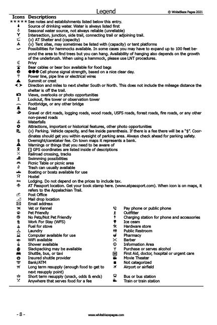
- Quick reference icons (65), located to left of descriptions makes it quick and easy to see what is at that location
- More mileage points. More than any other Appalachian Trail guidebook
- Entries, and town information all in sequential order. No flipping 2 or 3 pages forward, or backwards, to locate town information, unlike in other guidebooks
- Many more trail listings, such as side trails, waterfalls, bridges, views, power lines, attractions, and more
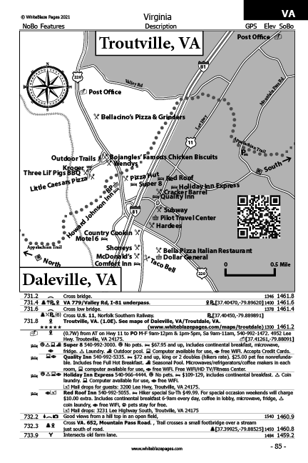
- Maps of trail towns with locations of establishments. Maps are to scale and in a north is up orientation
- Contains over 3,223 mileage points and thousands of establishments
- Establishments and their services are listed in order of road crossings/trail heads
- Phone numbers and web url's for every establishment when ever available
- Over 2,000 GPS coordinates in this book
- GPS coordinates to over 400 parking locations. Coordinates should always get you within eyesight of the parking area.Also parking lot quantities if known
- GPS coordinates to shelters, well-known landmarks, establishments, and attractions, trail heads and road crossings
- Post Office addresses listed under towns along with their GPS coordinates.
- All coordinates work in Google Earth
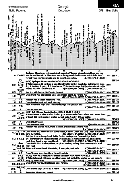
- Up to date elevation profile maps, in 30 mile increments, with quick-reference icons in reference adjacent to their location on the trail
- Pages easy to turn and trail data readily understood, page have with quick identification tabs in the top outer corners helping you get to where you want in the book quickly
- Includes the Appalachian Trails Conservancys shuttle provider listing and map
- Compare for yourself with other guidebooks. More data and pages. Lighter, thinner, and easier to read.
- The book now has the Approach Trail, including profile, elevations, coordinates, and Amicalola Falls State Park information.
- Over 2,000 GPS coordinates.
- Appalachian Trail Shuttle Providers listing and corresponding map.
- Interactive town maps available.
- Index in back of book listing all AT shelters, trail towns, some hostels and historic places.
- Index in back of book listing all town maps in the book.
- Quick reference to Resupply options along the Appalachian Trail and their distances from the trail head.
- Quick reference to Hostels and campgrounds along the Appalachian Trail and their distances from the trail head.
- Calendar displaying holidays, festivals and events along the Appalachian Trail.
Better design
I believe I have designed this book to be more organized to better help the hiker. I added hundreds more mileage locations/references points, more than any other single Appalachian Trail guidebook. I also added more quick reference icons, also including them in the decrsiptions. I felt that adding more quick reference icons was a better way to go. This helps the hikers to look quickly at the icons rather then having to read the whole description write-up.

Mileage from South North
Listed mileage from South to North in the far left column.

Quick reference icons (more)
Included 66 icons for quick reference. I have put these icons to the left of the decription for easy identification. Some of the new icons include trail intersections/junctions, bridges, power lines, bear cables/box, summits, water falls, attractions, road crossings, railroad crossings, AT passport locations, no pets, WifI, work for stay.

Many more mileage/reference point
More mileage points. More than any other Appalachian Trail guidebook.

List of establishments near trail crossings
Establishments and their services are listed in the book in order of trail crossings.
Page identification tabs
Quick identification tabs in the top outer corners, helping you get to where you want in the book quickly.

Parking, shelter, and attraction coordinates
Includes over 2,000 GPS coordinates for shelters, parking, Post Offices, and attractions along the Appalachian Trail. Over 400 parking locations and GPS coordinates that will bring you to the parking area entrance whenever possible but should always get you within eyesight of the parking area.

Mileage from North to South
Listed mileage from North to South in the far right column.

Profiles
Elevation profiles are in 30 mile increments. Items on the profiles are printed in bold text on the data pages for quick reference.

Town maps
Maps of trail towns with locations of establishments. Maps are to scale and in a north is up orientation.
Shuttle provider listing
Listing os over Listing of over 100 shuttle providers that will help you get to your location, slackpacking, and Airports, Bus and train stations.